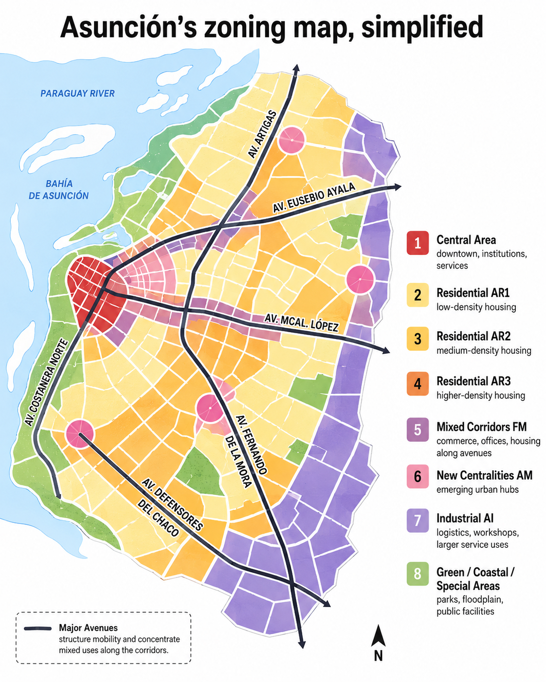
Asunción’s official zoning map is one of the most useful public documents for understanding how Paraguay’s capital can grow. It is also one of the hardest to read. The Plan Regulador uses colors, acronyms and legal references to show where housing, commerce, offices, industry, public facilities, green areas and special urban projects are expected or restricted.
For foreigners looking at property, business locations or urban development in Asunción, the key point is simple: the city is not regulated as one uniform area. Two blocks in the same neighborhood can have very different rules if one sits on a major avenue, near a park, in the historic center or inside a special-use corridor.
This explainer is a plain-language guide to the map’s logic. It is not legal advice and it does not replace a municipal consultation. Any decision about a specific lot still needs the cadastral account, exact location, current ordinance text and municipal criteria.
The Plan Regulador is the city’s zoning framework. It divides Asunción into categories and assigns rules for land use, building intensity, density, setbacks, parking and compatibility between activities. The municipality publishes the regulatory framework, including Ordinance 163/18 and later modifications, and a downloadable current zoning map called Plan Regulador Vigente.
The easiest way to read the plan is as a spectrum. At one end are low-intensity residential zones, where the main function is housing and neighborhood life. At the other end are central, mixed, commercial, industrial and special-use areas, where more movement, services, public facilities or larger developments are expected.
The central area, usually marked as AC, covers the traditional core of the city. It concentrates institutions, services, offices and commerce, and generally accepts more urban intensity than residential districts. That does not mean unlimited construction: heritage rules, traffic, parking, public space and building standards still matter.
Residential zones are commonly identified as AR1, AR2 and AR3. A practical reading is that AR1 protects quieter, lower-density housing areas. AR2 allows a medium level of residential intensity. AR3 permits more density and a more urban character, often making apartment buildings and compatible services more likely than in AR1 or AR2.
Many conflicts in Asunción happen at the edge between these categories. Residents may expect neighborhood protection, while developers or businesses look for more flexible rules. That is why it matters whether a property is inside a residential block, beside a mixed corridor or within a more intensive zone.
The mixed corridors, often marked as FM with different numbers, are especially important. They usually follow major avenues or strategic urban edges. In these places, the city accepts a mix of housing, commerce, offices and services. Being near a large avenue can therefore change the regulatory logic of a property even when it is close to quieter residential streets.
The map also includes mixed areas and new centralities, such as AM or related codes. These are places where the city can concentrate activity outside the old downtown. In theory, they can reduce pressure on the historic center by allowing services, housing and offices to grow in other parts of the capital.
Industrial zones, often marked AI, are intended for activities that do not fit easily inside residential neighborhoods: logistics, depots, workshops, larger service operations or industrial uses, depending on the exact rule. Specific-use areas, marked AUE or similar codes, are tied to major urban functions such as terminals, ports, hospitals, markets, government facilities or other large public equipment.
Green, coastal and environmentally sensitive areas should not be read as empty land. Around the river, streams, parks and flood-prone sectors, restrictions can be strong because the planning logic is connected to public space, environmental protection and risk management.
The map is confusing for three reasons. First, the abbreviations make sense to architects and municipal technicians, but not to most residents. Second, the colors are dense, and a single neighborhood can contain several zoning categories. Third, the color is only the start: the legal text behind the color defines the actual restrictions and exceptions.
For a quick first reading, ask five questions: is the property residential, mixed, central, industrial or special-use; is it on or near a major avenue; is it near a park, stream, coastal area or public facility; does the zoning allow only housing or also commerce and services; and have later ordinances modified the original rule?
The Plan Regulador matters because it shapes land value, investment, neighborhood change and the future form of the city. A more readable public version would help residents, foreigners, professionals and small businesses understand what applies to their block before they make costly decisions.